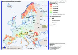
Mountain Areas and their accessibility, 2001
Europe’s mountain areas are in many ways of great importance as they comprehend a set of features to be considered as territorial potentials, in particular as water resource, they have an ecological, cultural and environmental diversity, which is an asset. Mountain areas are the most extensive natural areas in Europe and are very varied in character. Also in economic terms, mountain areas have different levels of GDP per capita, varying from 4.198 € to 46.358 € in 2003. A quarter of the population of the ESPON space lives and works in mountain areas which cover 39,8% of the territory. They contribute in total with 4,3% to the European GDP (EU 29 plus Norway and Switzerland). It is therefore important to look into the territorial features of these areas, in order to better understand specificities of the mountain areas.
Concept/method/measurement
The map gives focuses on potential multimodal accessibility from a European perspective, and on the presence of urban agglomerations within mountain areas. The concept of potential accessibility has been developed in order to cover several aspects in one indicator: the opportunities to be reached (in this case population) in a certain territory weighted by the effort in terms of time. In this case, multimodal accessibility expresses the combined effect of alternative transport modes, i.e. an aggregated picture of road, rail and air accessibility for a certain location.
Regarding the urban agglomerations, in particular the Functional Urban Areas (FUAs), corresponds to the basic description of the European urban system developed by ESPON, delineated on the basis of national definitions of travel-to-work areas. The 76 most powerful functional urban areas measured by demographic mass, competitiveness, connectivity and knowledge base are defined as Metropolitan European Growths Areas (MEGA).
Mountain areas were defined on the basis of the study "Mountain areas in Europe: Analysis of mountain areas in EU Member States, acceding and other European countries" developed by Nordregio to the European Commission. The map considers only NUTS 3 areas with at least 50% of mountainous areas. Mountain areas with high level of multimodal accessibility, i.e. equal to or above the ESPON average are represented in green. On the other side, the orange areas correspond to poor access levels in European terms. In this context, it is important to point out that the NUTS areas were considered as homogenous territories but in practise large differences in regional/local accessibility might exist, particularly due to the morphology of the mountainous areas. Finally, the yellow and orange circles correspond to FUAs within mountain areas and their colour and size varies according to their importance.
Interpretation
The easiest accessible mountain areas are found in the core of Europe or very close to the core, being concentrated in the Alpine region. In fact the Alps are among the most accessible mountain regions seen in a European perspective, together with some in Western Germany, Tuscany, Catalonia and Athens. The Alpine region includes several MEGAs and FUAs of transnational /national and regional/local importance. In contrast there are only two MEGAs in the less accessible mountainous periphery, Sofia and Bilbao.
On the other side, the peripheral mountain areas in the northern, western and Eastern parts of Europe, also including the Mediterranean region, are below the European average in terms of accessibility.
Conclusion
A European core-periphery picture holds true for the mountain areas and their accessibility. In general, the most central mountain areas, in particular the ones located in the Alpine region perform better in terms of potential multimodal accessibility. Besides this, in general, it seems that mountain areas benefit from the proximity to large urban agglomerations. In fact, the mountain regions close to MEGAs, except Sofia and Bilbao, appear as easy accessible in the European context.
Further reading: ESPON Atlas
