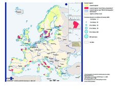
Coastal regions in Europe, 2004
One of Europe’s features is its multitude and diversity of coastal areas. Today 35% of the European population lives close by the sea. Of all regions at Nuts 3 level, 29% are considered coastal regions. Traditionally, coastal areas specialised in fishery and trade resulting in the development of numerous harbour cities along the coast. Large metropolitan regions have then grown along the waterfront together with a large amount of small and medium sized cities. Nowadays harbour functions of coastal cities have developed into a dense network of maritime transport.
The recreational assets of the coastal regions are in some parts of Europe being successfully explored supporting tourism. Many recreational areas with tourism facilities and secondary homes have been developed, particular in countries with high population density and/or warmer climatic conditions. However, the diversity of European coastal regions also includes vast coastal areas without significant human activity, particular in the northern periphery as well as technical installations in a limited number of locations along the coast.
Europe’s coastal areas face specific challenges in integrating human living, economic activities and environmental protection. It is therefore important to look at economic, social and territorial conditions of these areas, in order to better understand and respond to such challenges.
Concept/method/measurement
The map gives a European picture of three important conditions for the development of coastal territories. It focuses on fisheries dependency and on the presence of main European urban agglomerations within coastal regions. It also considers the existence and the size of commercial ports.
Coastal regions most dependent on fisheries are represented in red. These are areas that fulfil at least one of the following three criteria: a high share of fisheries employment in total regional employment, a high share of fisheries activity in the value added of the area or a dependency on species subject to management measures. The blue-dashed areas correspond to high demographic density coastal regions having Metropolitan European Growth Areas (MEGAs). MEGAs are the main European metropolitan agglomerations, according to a Functional Urban Areas typology developed by ESPON. Finally, the blue circles represent commercial ports, and their size varies according to the cargo volume in 2004, in millions of tonnes.
Interpretation
The most fisheries dependent territories present an image of a very marginal territorial fisheries sector. These areas appear scattered throughout Europe, although coastal regions in southern Sweden and in the Italian Adriatic coast come out particularly visible.
The presence of some high density urban agglomerations in coastal regions is clear, especially in western Mediterranean and Nordic countries, in important MEGAs such as Barcelona, Marseille, Roma, Kobenhavn, Stockholm and Helsinki. Curiously, the coastal territories located within the “Pentagon” (formed by London, Paris, Milan, Munchen and Hamburg) hardly include any MEGAs.
The map also reveals a dense European network of maritime transport. The largest commercial ports, such as Rotterdam and Hamburg, are located within the “Pentagon”, but other ports of important size appear scattered throughout the European coast, forming a network of maritime transport nodes with some concentration in the area of the English Channel and a less important network in Northern Scandinavia.
Conclusion
Coastal areas most fisheries dependent are in general peripheral areas in the European context and most of them are now experiencing declines in population, employment and income. In contrast, harbour functions have developed into a dense network of maritime transport, with large European harbours in the first league of the world harbour network.
Peripherality may be seen as a constraint for the European coastal regions but distance from centres of population and geographical constraints can become assets rather than liabilities, attracting tourism and other economic activities to the area. However, the increasingly high demographic pressure on some coastal regions where large metropolitan areas are located poses a severe threat to the environmental situation of these regions.
Further reading: ESPON Atlas, ESPON project 2.1.5/Fisheries
Documents
|
Map
|
|
|
ESPON Atlas, ESPON project 2.1.5-Fisheries.pdf
|